South East Asia Map
As seen on the South East Asia map, thousands of islands and a long arm of land make up Southeast Asia.
Mainland Southeast Asia
Mainland Southeast Asia includes the countries of Myanmar, Thailand, Laos, Cambodia, and Vietnam.
Plentiful water supplies and fertile soil enable farmers to grow rice as a major food crop.
Most of this area of Southeast Asia has tropical and subtropical climates.
Most mainland Southeast Asians live in rural villages, but cities are growing in population.
Most people in mainland Southeast Asia practice Buddhism.
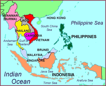
Myanmar, Thailand, Laos, Cambodia, and Vietnam lie entirely on the mainland. These countries have highland areas and lowland river valleys with fertile soil.
Island Southeast Asia
The island countries of Southeast Asia are Malaysia, Singapore, Brunei, the Philippines, and Indonesia.
Malaysia is rich in mineral resources. It also produces palm oil and rubber.
The people of Malaysia come from many different ethnic backgrounds.
Its capital, Kuala Lumpur, is a commercial center.
The port of Singapore is one of the world's busiest trading centers.
The city of Singapore is one of the world's busiest trading and commercial centers.
Brunei has rich deposits of oil and natural gas.
The Philippines is the only Christian country in Southeast Asia.
The culture of the Philippines shows Malay, Spanish, and American influences.
Indonesia is an archipelago of more than 13,600 islands.
Indonesia is the largest country in Southeast Asia in area and population.
It is the world's fourth most populous country.
It also has a strong economy based on large reserves of oil and natural gas, many mineral resources, and agriculture.
Islam is the major religion.
The islands of Southeast Asia lie along the Pacific Ocean's Ring of Fire.
Their people face the threat of volcanic activity and earthquakes.


