Philippine Map, Philippines Map, Philippines Maps
Geography and Philippine Map
The official name of the Philippines is the Republic of the Philippines.
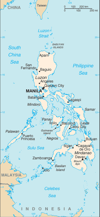
An archipelago located in the South China Sea, it consists of more than 7,000 islands. The island of Luzon in the northern region as seen on the Philippine map is where the capital Manila is. Eleven of the islands contain the majority of the population.
The climate of the Philippines is hot and humid all year around with temperatures averaging 25C (77F). The Philippines has 3 clear seasons: hot and dry during March-May; rainy season throughout June-November; and dry but cool from November-February.
A considerable amount of the surface area of the Philippines’ 300,000 sq. km. is hilly and mountainous. The Philippine Islands are home to about twenty restless volcanoes that are occasionally active, and there are also regular earthquakes and typhoons.
Population
About 85% of the Philippine population are Roman Catholic making it the largest Christian country in Asia. Approximately 5% of Filipinos are Muslim with the balance consisting of Protestant and various other religions.
Tagalog and English are the official languages and Spanish is also spoken and understood by a fairly large number of people. Across the Philippines about 80 various languages and local forms and dialects are spoken.
Predictions are that the population of the Philippines could double during the next 30 years due to the fact that it has one of the highest birth rates in Asia.
Women have a life expectancy of 72 years while for men it's 68.
Historical Background
Earliest Inhabitants
The Negritos were the original inhabitants of the Philippines and to date a human fossil has been found that is 22,000 years old.
Malayans started immigrating in consecutive numbers starting around 3000BC and today's Filipinos are mostly direct descendants of these people.
Colonial Period
Between 1542 and 1898 Spain reigned over the Philippines as part of the Spanish empire. King Philip II of Spain is in fact the namesake of the country.
In 1898 Spain handed over control of the Philippine archipelago to the U.S. as part of their concession to losing the Spanish-American War.
During the U.S. occupation of almost 50 years the American occupying force and the native population were involved in several battles.
As part of World War II the Philippines was attacked by Japan in 1941 setting off a 3 year occupation. General McCarthur and the U.S. forces liberated the Philippines via Leyte Island as shown on the Philippine Map, and Japan surrendered in 1945. The Philippine Islands were granted complete independence 1 year later and formally recognized as the Republic of the Philippines.


